Acushnet Center 🇺🇸
-
Nautical Twilight begins:05:25 amSunrise:06:24 am
-
Sunset:06:53 pmNautical Twilight ends:07:52 pm
-
Moonrise:12:26 am
-
Moonset:04:29 pm
-
Moon over:08:27 am
-
Moon under:09:04 pm
-
Visibility:26%
-
 Waning Crescent
-
Distance to earth:374,096 kmProximity:74.2 %
Moon Phases for Acushnet Center
-
good Day
-
major Time:07:27 am - 09:27 am
-
minor Time:03:29 pm - 05:29 pm
-
major Time:08:04 pm - 10:04 pm
-
minor Time:11:26 pm - 01:26 am
Tide Clock
Tide Graph
Times
| Tide | Time | Height |
|---|---|---|
| high | 03:53 am | 3.38 ft |
| low | 09:46 am | 0.66 ft |
| high | 04:26 pm | 4.27 ft |
| low | 11:19 pm | 0.59 ft |
| Date | Major Bite Times | Minor Bite Times | Sun | Moon | Moonphase | Tide Times |
|---|---|---|---|---|---|---|
|
Tue, 16 Sep
|
07:27 am -
09:27 am
08:04 pm -
10:04 pm
|
03:29 pm -
05:29 pm
11:26 pm -
01:26 am
|
R: 06:24 am S: 06:53 pm |
R: 12:26 am S: 04:29 pm |
Waning Crescent |
high: 03:53 am
, 3.38 ft
, Coeff: 98
low: 09:46 am
, 0.66 ft
high: 04:26 pm
, 4.27 ft
, Coeff: 144
low: 11:19 pm
, 0.59 ft
|
|
Wed, 17 Sep
|
08:21 am -
10:21 am
08:57 pm -
10:57 pm
|
12:39 am -
02:39 am
04:04 pm -
06:04 pm
|
R: 06:25 am S: 06:51 pm |
R: 01:39 am S: 05:04 pm |
Waning Crescent |
high: 04:56 am
, 3.61 ft
, Coeff: 110
low: 11:13 am
, 0.52 ft
high: 05:25 pm
, 4.33 ft
, Coeff: 148
|
|
Thu, 18 Sep
|
09:11 am -
11:11 am
09:46 pm -
11:46 pm
|
01:51 am -
03:51 am
04:32 pm -
06:32 pm
|
R: 06:26 am S: 06:49 pm |
R: 02:51 am S: 05:32 pm |
Waning Crescent |
low: 12:13 am
, 0.43 ft
high: 05:51 am
, 3.87 ft
, Coeff: 123
low: 12:16 pm
, 0.3 ft
high: 06:17 pm
, 4.4 ft
, Coeff: 151
|
|
Fri, 19 Sep
|
09:58 am -
11:58 am
10:32 pm -
12:32 am
|
03:01 am -
05:01 am
04:55 pm -
06:55 pm
|
R: 06:27 am S: 06:47 pm |
R: 04:01 am S: 05:55 pm |
Waning Crescent |
low: 12:54 am
, 0.26 ft
high: 06:40 am
, 4.17 ft
, Coeff: 139
low: 01:04 pm
, 0.13 ft
high: 07:03 pm
, 4.46 ft
, Coeff: 154
|
|
Sat, 20 Sep
|
10:41 am -
12:41 pm
11:14 pm -
01:14 am
|
04:08 am -
06:08 am
05:15 pm -
07:15 pm
|
R: 06:28 am S: 06:46 pm |
R: 05:08 am S: 06:15 pm |
New Moon |
low: 01:29 am
, 0.13 ft
high: 07:24 am
, 4.43 ft
, Coeff: 153
low: 01:44 pm
, 0.03 ft
high: 07:46 pm
, 4.43 ft
, Coeff: 153
|
|
Sun, 21 Sep
|
11:23 am -
01:23 pm
10:51 pm -
12:51 am
|
05:13 am -
07:13 am
05:34 pm -
07:34 pm
|
R: 06:29 am S: 06:44 pm |
R: 06:13 am S: 06:34 pm |
New Moon |
low: 01:57 am
, 0.03 ft
high: 08:06 am
, 4.59 ft
, Coeff: 161
low: 02:18 pm
, -0 ft
high: 08:26 pm
, 4.36 ft
, Coeff: 149
|
|
Mon, 22 Sep
|
12:04 pm -
02:04 pm
11:32 pm -
01:32 am
|
06:16 am -
08:16 am
05:53 pm -
07:53 pm
|
R: 06:30 am S: 06:42 pm |
R: 07:16 am S: 06:53 pm |
New Moon |
low: 02:24 am
, 0 ft
high: 08:45 am
, 4.63 ft
, Coeff: 163
low: 02:49 pm
, 0.03 ft
high: 09:04 pm
, 4.23 ft
, Coeff: 142
|


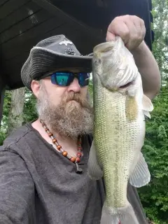
uploaded by: Heathen Monk

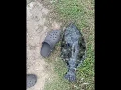
uploaded by: Flounder pounder

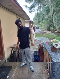
uploaded by: Stephen Spencer

uploaded by: Jon “Kuse”

uploaded by: Elzen Harris

uploaded by: RAMason69

uploaded by: Steven Butcheck

uploaded by: Joey Piercefield

uploaded by: Hoza

uploaded by: John Matthews
Best Fishing Spots in the greater Acushnet Center area
Wharf's or Jetties are good places to wet a line and meet other fishermen. They often produce a fresh feed of fish and are also great to catch bait fish. As they are often well lit, they also provide a good opportunity for night fishing. There are 1 wharf(s) in this area.
Mattapoisett Town Wharf - 8km
Beaches and Bays are ideal places for land-based fishing. If the beach is shallow and the water is clear then twilight times are usually the best times, especially when they coincide with a major or minor fishing time. Often the points on either side of a beach are the best spots. Or if the beach is large then look for irregularities in the breaking waves, indicating sandbanks and holes. We found 6 beaches and bays in this area.
Little Bay - 7km , Mattapoisett Town Beach - 9km , Brant Beach - 9km , Pico Beach - 10km , Grand Vue Beach - 10km , Nasketucket Bay - 11km
Harbours and Marinas can often times be productive fishing spots for land based fishing as their sheltered environment attracts a wide variety of bait fish. Similar to river mouths, harbour entrances are also great places to fish as lots of fish will move in and out with the rising and falling tides. There are 1 main harbours in this area.
New Bedford Harbor - 1km
We found a total of 97 potential fishing spots nearby Acushnet Center. Below you can find them organized on a map. Points, Headlands, Reefs, Islands, Channels, etc can all be productive fishing spots. As these are user submitted spots, there might be some errors in the exact location. You also need to cross check local fishing regulations. Some of the spots might be in or around marine reserves or other locations that cannot be fished. If you click on a location marker it will bring up some details and a quick link to google search, satellite maps and fishing times. Tip: Click/Tap on a new area to load more fishing spots.
New Bedford Harbor - 1km , Mill Pond - 1km , Hamlin Road Dam - 1km , Hamlins Pond - 2km , Tinkham Pond Dam - 4km , Popes Island - 5km , New Bedford Reservoir Dam - 5km , Crow Island - 5km , Fish Island - 5km , Dix Ledge - 6km , Turner Pond on High Hill Road Dam - 6km , Turner Pond Dam - 6km , Palmer Island - 7km , Sassaquin Pond - 7km , Little Egg Island - 7km , Little Bay - 7km , High Hill Reservoir Dam - 7km , Hartley Saw Mill Dam - 7km , Harley Millpond - 7km , Betty Spring - 8km , Mattapoisett Town Wharf - 8km , Shaws Cove - 8km , Wards Rock - 8km , Giffords Pond - 8km , Eel Pond - 8km , Pea Island - 9km , Old Kelick Rock - 9km , White Rock - 9km , Mollys Cove - 9km , Molly Cove - 9km , Mattapoisett Town Beach - 9km , Brant Beach - 9km , Mattapoisett Harbor - 9km , Hammonds Cove - 9km , Snows Pond - 9km , Twinings Pond - 9km , Egg Island - 9km , Pico Beach - 10km , Old Bartlemy - 10km , Ned Point - 10km , Moshers Point - 10km , Round Island - 10km , Mattapoisett Neck - 10km , Brant Island - 10km , Brant Island Cove - 10km , Low Bush Island - 10km , Long Pond - 10km , Clarks Cove - 10km , Clarks Point - 10km , High Bush Island - 10km , Cornell Pond Lower Dam - 10km , Grand Vue Beach - 10km , Edgewood Trust Number 3 Dam - 10km , Ram Island - 11km , Round Cove - 11km , Barstow Rock - 11km , North Point - 11km , North Cove - 11km , Nasketucket Bay - 11km , Mattapoisett Ledge - 11km , Long Island - 11km , Little Island - 11km , West Island - 11km , Cedar Dell Lake - 11km , Charles Christie Bridge - 11km , Seal Island - 11km , Leonards Pond Dam - 11km , Hathaway Pond Dam - 11km , Snow Rock - 11km , Snipatuit Pond - 11km , Gull Island - 11km , Gravelly Rock - 11km , Deep Point - 11km , Sunken Ledge - 11km , Randall Rock - 12km , Ricketsons Point - 12km , Pine Island Pond - 12km , Pine Island - 12km , Packet Rock - 12km , Nyes Cove - 12km , Marys Pond - 12km , Little Quittacas Pond - 12km , Sconticut Neck - 12km , Leonards Pond - 12km , Hiller Cove - 12km , Hemlock Point - 12km , Haskell Island - 12km , Strawberry Point - 12km , Goat Island - 12km , Gallatin Rock - 12km , Dartmouth Rock - 12km , Whale Rock - 12km , Wilbur Point - 12km , Black Point - 12km , Aucoot Cove - 12km , Angelica Rock - 12km , Black Rock - 12km
Comments